
 Peter Costello
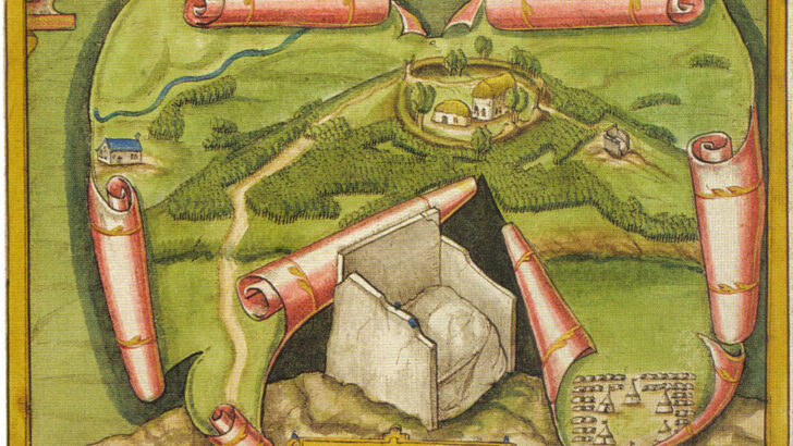 A vignette from a map of c. 1602 by Richard Bartlett, showing a native farmstead and the coronation chair of the O'Neill at Tullaghoge, Co. Tyrone
 Ireland: Mapping the Island,
by Joseph Brady and Paul Ferguson
(Birlinn, £30.00 / €34.99)
These days we take maps, and the knowledge of the real world that they display, very much for granted. This was always the case as this marvellous compendium of Ireland’s history as evidenced in cartography reveals.
The first printed map of the British Isles was made in Rome in 1546 by George Lilly, the domestic chaplain to Cardinal Pole, the last Catholic Archbishop of Canterbury.
On this appear three ships sailing by, with pennons in the breeze, whiskered monsters devouring fish near the Orkneys. This showed naturally enough the cities of Oxford and Cambridge, while to the east (to quote the poet Walter de la Mare) lies Ireland “beautifully vacant, with its few cities, eel-like rivers, scattered groves and sugar-cone mountains”. But also, in the northwest “an obscure, yawning cavern designated PVRGATORIUM ST PATRICII, with what might be the saint himself in the entry.”
Famous
That for the late Middle Ages Ireland was most interesting for that famous place of pilgrimage, not then for ordinary folk, but for those who were able to pay the levy demanded by the Augustinians who were its guardians.
But this book opens indeed with a brightly coloured map of Ireland alone made by the Dutchman Ortelius in 1581. Here too the Purgatory at Lough Derg is prominent among the details. Overall, the map is a joy to behold. But an earlier penny-plain map printed in Venice in 1560 actually shows a charming little drawing of the entry, to the original shrine, which was a visionary locus on Saints’ Island, and not as today, the penitential round on Station Island.
The history of Irish map making is the development of detail and precision: the monsters and holy places disappear to be replaced, as in Petty’s Down Survey of 1656 by details important to the new English settlers who were being planted across the island.
The main problem early map makers had was in getting the shape of the island right. Early maps failed to do this. On the west coast, for instance they showed a coastline much less intrusive into the Atlantic Ocean. In 1588 these maps misled the commanders of the Spanish Armada in their flight from the English fleet round the North coast of Ireland; they sailed south into what their maps suggested was clear water, only to be wrecked on the shores of Mayo and Kerry.
Irish maps slowly became clearer as to where everything was, and who owned or at least claimed the land. This was the main point of the Down Survey of 1656. This process reached its peak in the creation of the Ordnance Survey in the 1830s.
Originally these maps were on great sheets. But as people began to travel freely in the 19th century by rail to the seaside or the Donegal Highlands, they were issued in smaller pocketable folded sheets, a form ideal for the hordes of cyclists who arrived in the 1890s, the hikers who followed in the 1920s, and the middle-class car enthusiasts in the 1930s.
Specialised
These were specialised maps. Maps for particular clients were soon being created too. The most interesting of these were the insurance maps made by the Goad Company of Dublin, Cork, and other cities in the 1890s. These were not sold but were offered on a subscription basis, so that they could issue updates periodically, recalling and destroying the earlier versions, which is why they are now rare.
The maps do not reproduce well in the space available on our pages. But the early maps are filled with little vignettes which are of great interest. There is for instance the image of an Irish farmstead in the 1600 along with the coronation chair of the O’Neills.
It is these kinds of details on all the maps in this book that make its pages such a delight. The later chapters with details of urban growth and change are especially fascinating, for they reveal a process which we are still suffering through.
The last image shows Ireland as seen from outer space, the once almost unknown outline is now boldly clear, but the interior detail is still to be re-explored in the future.