
 Peter Costello
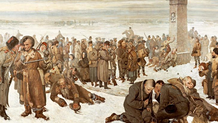 Prisoners arriving at a Russian labour camp in the 19th century.
 Pondering President Putin’s remarks on Russia’s role in history, I have come to think that some of Putin’s seemingly strange views might possibly be explained by the maps he used as a schoolboy.
Like so many educated people around the world, his picture of the world has been seriously distorted by the types of school atlases which were once used in schools in many countries, East and West.
Projection
These nearly always used a Mercator Projection. Most of the maps in atlases of, say, the British Empire used this projection, which has one major but highly distorting characteristic. The countries along either side of the equator are shown in their correct proportions. But as one moves north or south, countries are shown increasingly larger than they really are, due to the technical distortion of the system.
Hence the nations with empires about the time of the Great War found that the British Empire, of Canada, India and Australia were enlarged to show a greater size than they had in reality. Quite simply the maps were deceptive.
The same, of course, was true for Russia. The young Putin, born in 1952, looking through his atlas at School No. 193 at Baskov Lane, Leningrad, was able to see a huge Russia territory dominated by Moscow reaching from Poland across the Urals to the far distant Vladivostok. He gained the impression, which both the Tsars and later the USSR wanted their people to have, that Russia was a great nation, and on maps could be seen to be larger than the USA, and therefore the greatest nation in the world. He was quite simply deceived.
Bleak regions
Russians on the European side of the Urals never regarded the bleak regions of Asia as part of the “real Russia”. Siberia was not for them. From Tsarist days on the region was suitable only for exiling and punishing writers, anarchists, Nihilists, heretics such as the Doukhobors, savage tribes with strange beliefs, and untameable Muslims with a yen to murder Christians. A specific republic was created in a distant region as a “home” for Russian Jews, the first “proper” Jewish state in the modern world – few went there.
Siberia became in the popular imagination, a sort of realm of extended prison camps, later named by the long imprisoned writer Solzhenitsyn “the Gulag Archipelago”.
The Empire looked good in the school atlases, but was in reality for many “a place or state of punishment”.
The empires of the earth, the British, Spanish, Portuguese, Dutch, French and German, all these have vanished. Only two empires remain of those that existed about 1900, the Chinese and the Russian. Their wide claims to humane benevolence today are as specious as were those of those other empire builders.
Introduction
The Mercator problem was solved by the introduction in more sophisticated quarters of Azimuthally Equidistant projections. But these are for real geographers. Maps in newspapers, magazines and the electronic media are universally very poor today.
So be warned. As much care has to be taken in using a map as in reading a book. We have to ask why was this map made, who made it, and what is it trying to tell us, and what is it concealing?
All around the world military interests affect what is shown. In Siberia in the 1950s, a giant city, devoted to the secret manufacture of plutonium for advanced atom bombs, was not marked on any map, even its existence unadmitted until the 1990s. Maps, like books and Russian presidents, often wish not to inform but to mislead the world.