
 Peter Costello
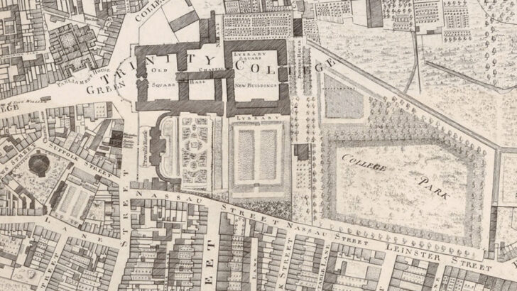 Dublin’s streets broad and narrow from John Rocque’s 18th Century map.
 Dublin: Mapping the City,
by Joseph Brady and Paul Ferguson
(Birlinn, £30.00/ €34.99)
This is a fine, solid, beautifully produced book, running to some 250 pages which will delight any one in any way interested in the history of Ireland’s capital as expressed in maps over the centuries.
The production values are high, fine paper, careful scanning and layout, effective design that is easy on the eye. One can see going well as a Christmas present, but it should not be seen as merely one of the ‘Xmas quickies’ that Irish publishers are so fond of.
Indeed it is produced by a Scottish publisher of great distinction as part of a series on important cities of these islands of which three have already appeared.
The authors are very well qualified for their task. Joseph Brady taught for many years in the School of Geography at UCD and is one of the preeminent authorities in the field. His co-author, Paul Ferguson, has been the long-time map librarian at TCD, curating a collection which he has carefully created over the last decades, and which is one of the real treasures of the university library.
Attitude
Now many people all too easily fall into the attitude that early maps are merely decorative which is a sad mistake. In this case the early maps, though very well illustrated and supported by detailed essays, are in fact the least important part of the book. John Speed, who published the first map of Dublin, is briskly dealt with, but John Rocque is explored with thoroughness as are all these maps of the 18th Century.
But it is with the maps from about the 1830s onwards, Victorian, Edwardian and modern, that the real interest of the book lies. The last 50 pages are truly revealing to those who struggle to understand the city they live in.
What is illustrated is the growing complexity of the city, social, spiritual and intellectual. The networks of narrow lanes inherited from the Norse and the Normans are shown broadening – the wide Street Commissionaires of the 1780s were truly named and in O’Connell Street their work is still visible.
Whereas in say Rocque the churches stand out among the buildings, by the 1890s there they were challenged by the factories, the department stores, the large distilleries and breweries, where spirits, beer, bread and biscuits were made. The maps illustrate the constant challenge of the new for constant renewal, a process that still goes on but at a quicker rate.
Beginning with 1900 and a map of the tram service we see the emergence of the modern city, one still using gas, but now suffused by the electricity initially provided by the generators of the tram company, later by a state service. The old city took its quota of victims as seen in a 1906 map of the very high death rate in the innermost parts of the city.
But by the time of the Great War city planners were at work seizing upon the possibilities of relaying the city. The opportunity for reconstruction followed upon the revolutionary years. A map of Marino offered a glimpse of the new suburbs that would emerge and continue to expand.
Fascination
I hope I have indicated in some small way the fascination of what is revealed by the authors on the basis of their decades long research. But in truth I found those last 50 pages I mentioned, which one would have expected to merely cover what we all know, to be full of detailed discussion of local areas such as the Grand Canal Dock scheme, which still seems to some in Dublin 4 to be an intrusive and inhuman creation.
This is a book wonderfully filled with information, written with a crisp clarity which is not always the case with academic books. Perhaps by learning about how what we have was developed over the last two lifetimes, we will make a better job, or at least a more humane one, of what is to come for the future citizens of Dublin.